
In cooperation with:

![]()
Prologue
| Portugal in the Middle Ages
| Conditions at the Start
| Voyages of Discovery
Cartography and Nautics
| New Worlds Old Empires
| Portugal Overseas
| Art and Curiosity Cabinets
Portugal in the 16th Century
| International Conflicts
| Foreign Images
The beginning of Portuguese expansionism was marked by traditional political constellations and forms of knowledge. In the Middle Ages, geographical notions about the world were long based on the works of the writers of antiquity. The extent and spherical form of the earth had been known since ancient times. This knowledge was not lost in the Middle Ages. The first nautical maps of the Mediterranean were made in the 13th century. Translations of classical texts from Arabic back into the original further enriched the stock of knowledge in Europe. It was above all the “rediscovery” of the writings of Ptolemy which led to a decisive rise in the development of geography.
At first the Italian city-states dominated the trade in spices. The Egyptian Mamelukes, who ruled the Red Sea and large parts of the Levant, acted as middlemen in the trading of goods from Asia. Their hegemony was increasingly threatened by the Ottomans. Thus, the only possibility for Portugal to participate in the lucrative trade with the Far East was to discover a new transport route.
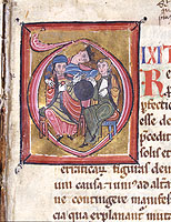
Opus Quadripartitum, Claudius Ptolemäus, Übersetzung aus dem Arabischen ins Lateinische, Westfrankreich?, 2. Hälfte des 12. Jahrhundert,
Wiesentheid, Kunstsammlungen Graf von Schönborn
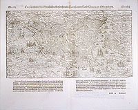
Stadtansicht von Konstantinopel, Aus: Sebastian Münster, Cosmographia, Basel, um 1550
Berlin, Deutsches Historisches Museum
