
In cooperation with:

![]()
Prologue
| Portugal in the Middle Ages
| Conditions at the Start
| Voyages of Discovery
Cartography and Nautics
| New Worlds Old Empires
| Portugal Overseas
| Art and Curiosity Cabinets
Portugal in the 16th Century
| International Conflicts
| Foreign Images
1. Navigation and Portuguese Cartography
Portugal’s overseas discoveries went hand in hand with decisive advances in nautical science and cartography. Ships fit for the high seas were first built in Portugal when Henry the Navigator began undertaking his voyages to Africa. Portuguese mathematicians and astronomers developed methods of determining nautical positions on the open sea. By the middle of the 15th century navigators were already able determine the latitude of their ship by means of the stars. At the same time German scientists were also occupied with methods of using the heavenly bodies for purposes of orientation. Johannes Regiomontanus made a significant contribution by calculating the ephemerides, or planetary tables. The new techniques and practical experience of the sailors also affected European cartography. Unknown regions received precise geographic contours for the first time. Findings gained through the voyages of discovery led to comprehensive corrections and extensions of the Ptolemaic view of the world.

Seekarte
João Teixeira Albernaz (gest. nach 1652)
Portugal, 17. Jahrhundert
Illuminiertes Pergament
Lissabon, Instituto dos Arquivos Nacionais / Torre do Tombo
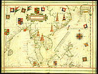
Ostasien im Atlas des Fernão Vaz Dourado, Portugal, um 1576
Lissabon, Biblioteca Nacional
2. Reception and Further Development in Central Europe
The results of the Portuguese discoveries aroused great interest in southern and central Europe as well. Besides merchants, it was above all the Humanists who advanced the rapid spread of new ideas through their scientific reception, translation and printing of the reports. The city of Nuremberg is the most prominent example of the response to the voyages of discovery in Germany. Martin Behaim, who had stayed in Portugal for a long period of time, had the oldest extant globe of the world built in Nuremberg in 1492/93. Jobst Ruchamer translated the first collection of reports on the early Portuguese discovery voyages into German. At the beginning of the 16th century Martin Waldseemüller developed his landmark contributions to cartography within the Humanistic circle at the Gymnasium Vosagense in the town of St. Dié in Lorraine.
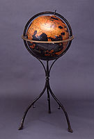
Globus des Martin Behaim (Faksimile), Ende 19. Jahrhundert (Original Nürnberg 1492–1493/94)
Berlin, Deutsches Historisches Museum
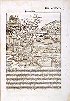
Weltchronik des Hartmann Schedel, Nürnberg, 1493
Berlin, Deutsches Historisches Museum
