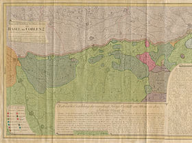
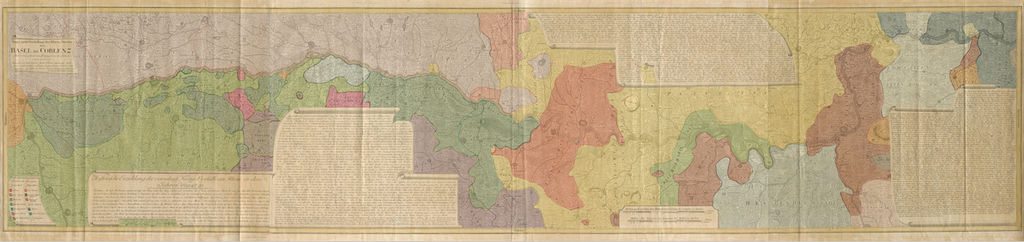
The Rhine from Basel to Koblenz

Entirely new depiction of the Rhine river 1794
  • Entirely new depiction of the Rhine river 1794
  • Details of the historical map
  • French-German history alongside the Rhine
  • Chronologie der deutsch-französischen Geschichte

Media library

deenfr Media library
deenfr Menu
yeahShip types
  • Milestones in the history of European shipbuilding
yeahMerian's Germany 1642 - 1654
  • Interaktive Karte
  • Image gallery
  • Imprint
  • Wissenswert
yeahThe Rhine from Basel to Koblenz
  • Entirely new depiction of the Rhine river 1794
  • Details of the historical map
  • French-German history alongside the Rhine
  • Chronologie der deutsch-französischen Geschichte
yeahWeimar: The Essence and Value of Democracy
  • Government programme
Weltwirtschaftskrise
DHM Screen
Filter

Territories in 1794

Here on the historical map you can see the borders of the regions named below.

Show all
Electorate of Cologne Electorate of Mainz Electorate of Trier Electoral Palatinate Margraviate of Baden Duchy of Württemberg Breisgau (Further Austria) Priory of Heitersheim (Breisgau) Bishopric of Speyer Bishopric of Straßburg Bishopric of Worms Principality of Nassau Lords of Eppstein Free City of Frankfurt Landgraviate of Hesse-Darmstadt Landgraviate of Hesse-Kassel Principality of Fürstenberg Alsace (France) Palatine Zweibrücken (France) Canton of Basel (Swiss Confederacy) Mulhouse (Swiss Confederacy)
Image Description
Entirely new depiction of the Rhine river from Basel to Koblenz, Map by Peter Joseph Moritz Pedetti, Nuremberg, Germany 1794, DHM Do 54/194
  • Imprint

© Deutsches Historisches Museum